

Microwave Remote Sensing Instruments Used for Monitoring Wetlands
Spaceborne microwave remote sensing offers effective tools for characterizing wetlands, as microwave sensors are particularly sensitive to surface water and to vegetation structure, allowing monitoring of large, inaccessible areas on a temporal basis regardless of atmospheric conditions or solar illumination. Inundated wetlands can be consistently mapped and characterized with microwave remote sensing instruments, employed alone or in combination.
Synthetic Aperture Radar (SAR)
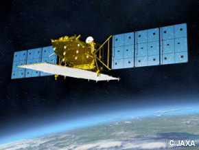
ALOS PALSAR, ALOS-2 PALSAR-2, JERS-1
The Phased Array type L-Band Synthetic Aperture Radar (PALSAR) was one of the three remote-sensing instruments onboard the Advanced Land Observing Satellite (ALOS) launched in January 2006 by the Japan Aerospace Exploration Agency (JAXA) for characterizing land cover and for disaster monitoring. ALOS PALSAR operated until 2011. Its successor, ALOS-2 PALSAR-2 was launched in May 2014 and is currently operational. Its predecessor, the Japanese Earth Resources Satellite-1 (JERS-1) operated from 1992 through 1998.
The SAR instruments used by the JERS-1, ALOS PALSAR and ALOS-2 PALSAR-2 missions are active L-band (~1.25 GHz) microwave sensors capable of operating day and night over any weather. PALSAR and PALSAR-2 support Fine Beam and ScanSar data collection modes that allow the sensor to acquire fine-resolution data or large swaths of multi-temporal acquisitions at reduced spatial resolution. In addition, PALSAR and PALSAR-2 can acquire fully polarimetric SAR imagery. Such technology allows for a variety of applications ranging from the determination of soil moisture and vegetation classification, to the monitoring of environmental disasters.
(eorc.jaxa.jp)
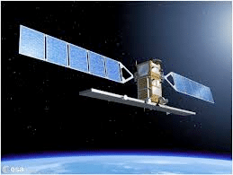
Sentinel-1
The ESA Sentinel-1 mission is composed of two satellites, Sentinel-1A and Sentinel-1B, that carry C-band (5.4 GHz) SAR instruments. The first satellite, Sentinel-1A, was launched in April 2014, and Sentinel-1B was launched in April 2016. Both are currently operational. There are a wide range of applications for the data collected via the Sentinel-1 mission, including sea and land monitoring, emergency response due to environmental disasters, and economic applications.
(sentinel.esa.int)
Coarse-Resolution Active and Passive Microwave Sensors
AMSR-E, AMSR-2
The Advanced Microwave Scanning Radiometer (AMSR) has operated on two satellite platforms:
- AMSR-E operated on NASA’s EOS Aqua spacecraft, launched May 4, 2002. The instrument ceased effective operation on Oct 4, 2011.
- AMSR-2 is deployed on-board JAXA’s GCOM-W1 spacecraft, launched May 18, 2012. This instrument is currently operating.
The AMSR instruments are multi-frequency, dual-polarization, conically scanning passive microwave radiometers providing global-scale diurnal sampling. The primary objective of these missions is to gather large-scale information about Earth’s water systems, acquiring data for analysis of global precipitation, evaporation, and the cycling of water. Such information is vital for scientists around the world seeking a better understanding of Earth’s water cycle and its dependence on global climate.
SSM/I and SSMIS
The Special Sensor Microwave Imager (SSM/I) and the Special Sensor Microwave Imager Sounder (SSMIS) are passive microwave radiometers. These radiometers have been deployed on-board the Defense Meteorological Satellite Program (DMSP) series of satellites since 1987 with the series currently on-going.
ERS-1, ERS-2
The European Space Agency’s (ESA) two European Remote Sensing (ERS) satellites, ERS-1 and –2, were launched in 1991 and 1995 respectively. Their payloads included a microwave sensor package that supports SAR imaging, radar scatterometry, and radar altimetry. The ERS-1 mission ended in March 2000 and ERS-2 was retired in September 2011.
(eospso.nasa.gov)
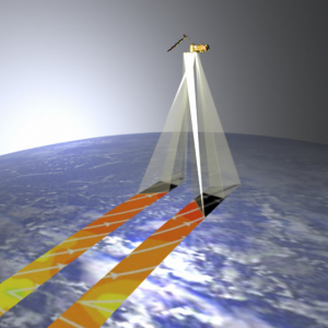
QuikSCAT
The SeaWinds instrument on NASA’s Quick Scatterometer (QuikSCAT) was used as a “quick recovery” mission to fill in the data gap that resulted when the satellite carrying NASA’s scatterometer (NSCAT) lost power in June 1997. QuikSCAT was launched in June 1999 and the mission officially ended in Nov 2009. It was a specialized microwave radar with a rotating dish antenna providing scatterometer measurements at 13.4 GHz. The instrument acquired global data over a continuous, 1,800 km-wide swath covering 90 percent of Earth’s surface each day.
ASCAT
The first Advanced Scatterometer (ASCAT) was launched on ESA’s EUMETSAT MetOp-A satellite in October 2006. A second ASCAT instrument became operational on MetOp-B, launched in September 2012. Both currently operational, MetOp-A and MetOp-B carry identical ASCAT instruments. The main objective of ASCAT is the measurement of wind speed and direction over the oceans, though ASCAT is also used for studying polar ice, soil moisture, surface hydrodynamics, and vegetation. ASCAT is a C-band scatterometer with two sets of three vertically polarized antennas, with a set extending on each side of the instrument, resulting in dual swath observations, each swath being about 500 km wide.
(esa.int)
