

The Sentinel-1 SAR observation plan implements a baseline pre-defined mission observation scenario, making optimum use of the SAR duty cycle within the technical constraints of the overall system. This scenario aims at fulfilling, during the routine exploitation phase, the observation requirements of the Copernicus services and of ESA/EU member states. In addition, on a best effort basis and with lower priority, a secondary objective is to satisfy other SAR user communities, ensuring continuity of ERS/Envisat, considering requirements from the scientific community, as well as from international partners and cooperation activities.
High-Level Observation Plan: Highlights
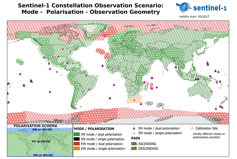
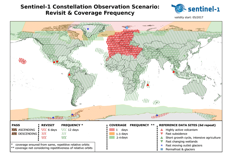
Observation Scenario Maps
The maps below describe Sentinel-1 observation scenarios as of May 2017. These maps will be updated regularly. Wave mode, operated by default over open oceans, is not shown. See the ESA archive for a full list of Sentinel-1A observation scenario maps dating back to the start of the operations ramp-up phase (September 2014).
Excerpts below are from the Sentinel High Level Operations Plan (scroll down at that link), on a repeat-cycle basis.
European coverage:
A full two-pass (ascending and descending passes, providing at least two acquisitions for each area within 12 days) coverage in IWS mode, VV-VH polarization is provided for Europe in the extent of EEA-39 member states every 12 days to provide data for a variety of services and applications. In addition, for European marginal seas high coverage frequency following distinct clustered requirements in IWS mode, VV-VH polarization is provided within each 12 days. An exception is for the Baltic Sea, observed partially in EWS during northern winter, on descending passes, to support sea-ice monitoring activities.
Polar environments monitoring:
Major global sea-ice zones will be observed to satisfy in particular the needs from the Copernicus Marine Environment Monitoring Service i.e.: EWS mode, HH or HH-HV polarization with some gradual increasing revisit frequency as triggered by the requirements and limited by technical constraints.
Major global ice-caps are covered at least once a year according to local winter conditions, employing IWS mode, HH polarization, and achieving at least three to four consecutive full coverage.
Worldwide coverage:
All global landmasses are regularly covered following a zonal concept in a stable one-pass IWS mode, VV-VH polarization. Zones delineation basically follows climatic-geographical considerations. Zones boundaries are extrapolated to follow administrative boundaries to provide consistent countrywide wall-to-wall coverage. During initial operations, the acquisition of distinct zones is triggered by the approach to derive a background reference dataset, among others suitable for flood monitoring during locally dry conditions which also provide the most stable radiometric conditions. The revisit frequency for all zones increased in line with the gradual mission capacity increase.
Tectonic and volcanic active areas:
Global tectonic and volcanic active areas (following an area extent definition provided by key scientists of the domain) are observed in a stable full two-pass IWS mode, VV polarization coverage with a revisit frequency of 24 days per pass (alternating ascending and descending passes, i.e. a particular area is observed every 12 days, interferometric pairs are available every 24 days). Global tectonic and volcanic active areas located within Europe are revisited within 12 days per pass in IWS mode, VV-VH polarization.
Forestry, Agriculture, Soil moisture retrieval and other specific environmental monitoring:
Key project sites all around the globe focusing on specific topics are supported from the first repeat cycles in IWS mode, with a default polarization in VV-VH, and revisit frequency individually tailored to the specific needs as far as possible.
Calibration and validation activities:
Aiming at the best achievable data quality of Sentinel-1 products, calibration and validation activities are routinely performed during the routine operations phase. These priority activities may locally and temporarily interfere with the delivery of coverage in consistent mode-polarization combination. Major regions affected by these activities are Northern Alpine Lowlands (Germany, Austria and Switzerland) and the narrow surroundings of Sao Paulo (Brazil), Houston and Chicago (USA). Limiting the consistency of static mode–polarization coverage and causing small observation gaps due to instrument switches, these activities bring the opportunity to explore the variety of the Sentinel-1 image modes to data users of the affected areas.
Content on ASF’s Sentinel web pages is adapted from the European Space Agency (ESA) Sentinel website.
